Hiking Expedition Through Mayflower Gulch: Exploring Abandoned Towns and Majestic Mountains
Nestled near Copper Mountain in Colorado, the Mayflower Gulch trail is more than just a hike; it's an open invitation to explore a high-altitude playground shaped by glaciers and time. This trail, a part of the Top of the Rockies Scenic Byway, offers a sense of adventure that transcends traditional hiking paths.
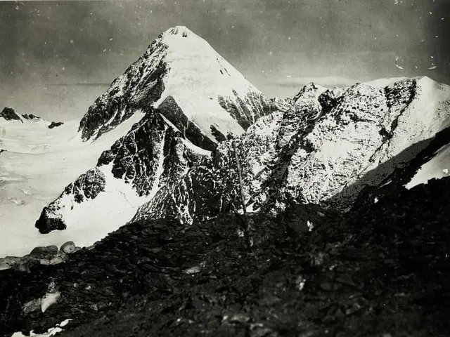
Once you step out of the trees, you're greeted by a sprawling amphitheater of jagged peaks, winding streams, and the vestiges of the Boston Mine. The entire trail, stretching up to 6 miles with a 1,500 feet elevation gain, is not so much a designated route as it is an invitation to wander at your own pace.
From Highway I-70, take exit 195 towards CO-91/Copper Mountain/Leadville. Continue on CO-91, which forms part of the Top of the Rockies Scenic Byway, for about 5.9 miles. The trailhead, marked by an obvious parking area and a trailhead bulletin board, is on the left. Low-clearance or two-wheel-drive vehicles can park here. Those with 4WD/AWD vehicles and sufficient clearance can venture further down an old mining road to save a mile of walking.
A large dip at the start of the road may pose a challenge; if you're unable to navigate it, park off the road or return to the parking area. Regardless of whether you walk or drive, you'll pass a collapsed cabin on your left and the foundations of an ore shoot on your right. After about a mile, you'll find a large gate blocking the road. Park here and continue on foot to reach the cabin ruins, approximately 50 yards ahead.
These ruins are remnants of the Boston Mining Camp, active from around 1884-1900 when a large gold vein was discovered near Fletcher Mountain. The mining boom ended abruptly when the vein was found to lack purity, and the miners dispersed in search of more prosperous opportunities. Fast forward to 2009, when the Summit County Open Spaces & Trails Department acquired the Mayflower Gulch area, paving the way for its preservation despite the millions of dollars worth of gold believed to be buried beneath the surface.
The main attraction in Mayflower Gulch is the mining cabin ruins past the large gate. They sit at around 11,500 feet in elevation and are encircled by jagged mountain peaks, including Fletcher Mountain, Crystal Peak, Pacific Peak, and more. This high elevation meant treacherous winter conditions, including avalanches, harsh winds, and snow for most of the year. Even in late August, a hiker might find themselves treading through fresh snow.
Take time to absorb the history, or perhaps even a few ghosts. The trail winds deeper into the amphitheater, with further exploration leading to additional building ruins and a cable connecting a mine entrance to a building above. Whether your interest lies in the views, history, or simply the joy of wandering, Mayflower Gulch is worth returning to again and again. Bring your hiking boots, curiosity, and a camera. Most importantly, allow for some extra time to fully immerse yourself in this spectacular destination.
For those seeking a deeper dive into the area's history, consider bringing a copy of Mary Ellen Gilliland's local history book, "Summit, A Gold Rush History of Summit County, Colorado," available at the Frisco bookstore. In the winter, the mining roads become a cross-country skiing and snowshoeing trail, offering a different kind of adventure. However, hikers should be aware of potential avalanche risks.
Nearby hiking suggestions include Clinton Gulch Dam Reservoir, Shrine Ridge, and Wheeler Lakes. A day spent in the nearby town of Leadville, the highest incorporated city in North America, will provide additional historical and recreational experiences, such as visiting the National Mining Hall of Fame and exploring the Top of the Rockies Scenic Byway.
- The Mayflower Gulch trail, situated near Copper Mountain in Colorado, offers more than just a hike; it's an invitation to explore a high-altitude playground, featuring jagged peaks, winding streams, and historical sites like the Boston Mine.
- The Mayflower Gulch trail, part of the Top of the Rockies Scenic Byway, stretches up to 6 miles with a 1,500 feet elevation gain, inviting wanderers to delve into its amphitheater of breathtaking scenery at their own pace.
- For hikers eager to learn more about Mayflower Gulch's history, Mary Ellen Gilliland's local history book, "Summit, A Gold Rush History of Summit County, Colorado," is recommended and available at the Frisco bookstore.
- Beyond exploring the Mayflower Gulch trail, nearby destinations like Clinton Gulch Dam Reservoir, Shrine Ridge, and Wheeler Lakes provide additional hiking opportunities, while the town of Leadville, the highest incorporated city in North America, offers historical and recreational experiences including the National Mining Hall of Fame and more.


